


ModiinApp was started as a small project by 4 friends (three of us live in Modiin - 2 olim and 1 sabra), and quickly grew into the best source for information on local businesses and deals in Modiin. Everything we do is local and authentic. We hope you like it. Get in touch!
e.g. Restaurants, Taxis or a business name
Categories
Hot & Most Popular
Leisure & Shopping
Home & Family
Business, Finance & Law

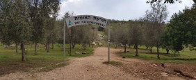
Givat HaTitora
Between the road to Maccabim-Reut and the streets: Emek Ayalon, Klil HaChoresh & Emek Dotan.
Last Updated:
over 2 weeks ago

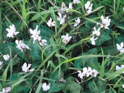
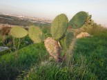
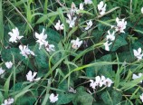
A perfect family hike in the heart of the city. The best time to visit the hill is between November and April, when it is full of beautiful wild flowers and blossoming almond trees.
Givat HaTitora is the main and most important nature, scenery, and heritage site of its kind in the city of Modiin Maccabim Reut, and offers a variety of points of interest: scenic viewing points, general and military history, archaeology, and animal and plant life.
The hill, which covers around 600 dunam, is located on the north-eastern border of the city, and reaches a height of 315 meters above sea level.
Directions
You can park your the car at the top of the hill and start there, or park on one of the streets around the hill and walk up the hill from there.
Entry for cars is on Klil HaChoresh opposite Migdal David. Drive around 100 meters to the top of the hill, where next to the water reservoir there is a parking area for around 40 cars, from where you can start a tour of the hill.
For pedestrians there are a number of main paths:
- From Emek Dotan next to the Ofek school
- At the end of 'Shvil HaPrachim' that starts at the junction of Emek Dotan and Klil HaChoresh (opposite Holmes Place)
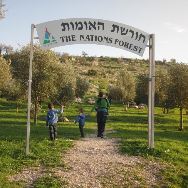
- On Emek Ayalon, corner of Shomrey HaChomot, through 'Churshat HaUmot'
For those interested in a more challenging walk, it is recommended to park your car on Emek Ayalon next the Modiin Center and walk up from there.
This walk is steeper and longer, and also displays Givat HaTitora in its full glory. When you reach the top you will not only discover a breathtaking view behind you, of the western side of Modiin and beyond, you will also feel the satisfaction from the climb, and all this before you have even started to tour of the hill itself.
Trail markings
In November 2018, a team of official trail markers from the committee for the marking of Shvil Yisrael came to Givat HaTitora.
This team came to mark one trail on the hill, which will connect the trails that have been marked until now in three different colors - black, green and red.
The color of the new marked trail is green, and it encircles Givat HaTitora in a natural way in a 2 km walk. This path is intended for an enjoyable walk for those that love nature and hikes, and is not accessible.
The trail includes an abundance of vegetation, cisterns and agricultural terraces, with beautiful blossoms of anemones and cyclamens along the trail during the winter months.
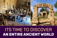
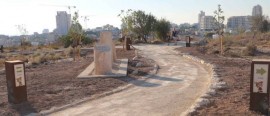
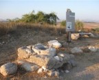
The archaeological garden
In August 2018 accessibility arrangements as well as the establishment of an archaeological garden were completed on the hill, including:
- A central trail encircling the hill, accessible for hikers and visitors
- Directional and informational signs, and audio information stations in Hebrew and English.
- Shaded areas with vines, seating areas, learning spaces and scenic viewing points of the city and the area.
- Amphitheater with 150 seats overlooking the area north of Modiin.
The archaeological garden displays agricultural equipment and architectural items that were discovered in digs carried out on the hill and in the Modiin area, with explanation signs situated next to each item.
These findings attest to the uniqueness and importance of the region in the history of the Land of Israel, especially in the Iron Age and the Second Temple period.
The remains of an agricultural settlement were uncovered on Givat HaTitora - farms that had both a familial and industrial character, and that were adapted to the local conditions, as well as hiding caves, cemeteries, quarries, equipment, cisterns and an ancient road.
The Ancient Modiin?
(Written by the archeologist and tour guide, Danny Herman).
Located in a dominant position, controlling the main road to Jerusalem via the Beth-Horon ascent.
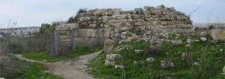
At the top, the remains of a Crusaders fort can clearly be seen. Its original name, "Tantara", was adapted in Arabic to "Tanturah" and the Hebrew to "Titura" (brimmed hat).
During the 1990's Dr. Shimon Gibson, on behalf of the Antiquities Authority, conducted several excavations at the site. He believes that Titora Hill is the location of ancient Modi'in. He also exposed remains from the Israelite period, and many hideouts from the time of the Bar-Kokhba rebellion.


Contact
Recommendations
Related Pages

Danny Herman - Private & VIP Tours, Archaeological Expertise
3
Modiin General
Private and VIP tours to all of Israel, by an archaeologist and a tour guide. 15 years of experience and many recommendations. Lecturer at the Hebrew University, IDC, and Tour guide courses

05/05 : Archaeological Happening On Titora Hill [Free]
2
Prachim
Archaeological happening for the whole family. Program: Experience archaeological digging Craft workshops led by the Antiquities Authority Guided tour of the ancient wine press Exhibition of archaeological findings Please come with closed s

09/07 : Sparks of Charcoal and Color at Givat HaTitora - Summer 2026
Prachim
A long-exposure photography and charcoal drawing workshop - a nighttime experience of light, movement, and creation at Givat HaTitora. Join an extraordinary event that brings together modern photography technology and an ancient drawing med